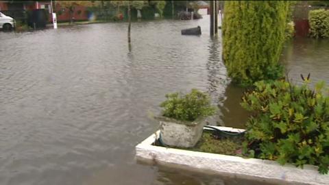
Flood-ravaged Christchurch is under deluge again today, with 50mm falling in the past 24 hours, heavier than was forecasted.
The Heathcote River has breached its banks in places, causing some road closes, Christchurch City Council says.
The ...
Video Player is loading.
Current Time 0:00
/
Duration 0:00
Loaded: 0%
0:00
Stream Type LIVE
Remaining Time -0:00
1x
Chapters
descriptions off, selected
captions settings, opens captions settings dialog
captions off, selected
This is a modal window.
Beginning of dialog window. Escape will cancel and close the window.
End of dialog window.
This is a modal window. This modal can be closed by pressing the Escape key or activating the close button.
Herald NOW: How to unlock economic value by maximising land use
UP NEXT:
NOW PLAYING • Flood-ravaged Christchurch
Flood-ravaged Christchurch is under deluge again today, with 50mm falling in the past 24 hours, heavier than was forecasted.
The Heathcote River has breached its banks in places, causing some road closes, Christchurch City Council says.
The ...
The Flockton Basin area, flooded three times in less than two months, is again under water in many places.
Geotechnical consultants are monitoring known risk areas.
"The council is asking people in hillside areas to be vigilant, and keep an eye out for any telltale signs of land instability, including new cracking to land, buildings, driveways or paths; existing cracks that get longer, wider or deeper; leaning or bulging of retaining walls; or rockfalls.
If anyone notices changes, or has concerns, they are being urged to call the council's call centre on 941 8999, or 0800 800 169.
Road closure information is continually changing. For up-to-date traffic information throughout Christchurch city and Banks Peninsula, please visit the Transport for Christchurch website at www.transportforchristchurch.govt.nz
Otago flooded
North Otago bore the brunt of the latest low to slide across the east coast, with 60mm of rain falling in 24 hours.
State Highway One at Hilderthorpe, north of Oamaru, is closed this morning and detours are in place.
Further north, widespread surface flooding has closed some streets in Christchurch.
Herald NOW: How to unlock economic value by maximising land use
Ryan Bridge speaks with Prof. Alan Renwick on how to maximise land use for economic gain.
Video / Herald NOW
Video Player is loading.
Current Time 0:00
/
Duration 0:00
Loaded: 0%
0:00
Stream Type LIVE
Remaining Time -0:00
1x
Chapters
descriptions off, selected
captions settings, opens captions settings dialog
captions off, selected
This is a modal window.
The Video Cloud video was not found.
Error Code: VIDEO_CLOUD_ERR_VIDEO_NOT_FOUND
Session ID: 2025-05-29:9f3a26fcba9d21474a84bc0 Player Element ID: vjs_video_3514285471001
Beginning of dialog window. Escape will cancel and close the window.
End of dialog window.
This is a modal window. This modal can be closed by pressing the Escape key or activating the close button.
Herald NOW: How to unlock economic value by maximising land use
UP NEXT:
NOW PLAYING • Herald NOW: How to unlock economic value by maximising land use
Ryan Bridge speaks with Prof. Alan Renwick on how to maximise land use for economic gain.
Video / Herald NOW
MetService said 45mm of rain has fallen in the last 24 hours and another 20mm is expected this morning.
Yesterday, the Waitaki District Council activated its Civil Defence emergency operations centre at 2.30pm, as the rain continued to bring high river levels and caused surface flooding in North Otago.
Just south of Oamaru, 53mm fell at the Dasher in the 24 hours to 5pm yesterday.
Civil Defence local controller Murray Linwood said Pukeuri, Hilderthorpe and Alma had the worst surface flooding yesterday.
The Kakanui River at Clifton Falls peaked at 200 cumecs and was falling at 8.20pm.
All roads in the Corriedale ward network were closed, along with another six rural roads - Bobbing Creek Rd, Elderslie Rd, Herbert Rd, Paterson Rd, Turfus Camp Rd and Weston-Ngapara Rd.
Caution was urged on State Highway 83 from Pukeuri to Duntroon, with some areas closed to light vehicles.
Mr Linwood said more costal rain meant affected areas differed from Easter's flooding event.
The Oamaru Volunteer Fire Brigade was called to sandbag and pump water from houses on Eden St, Beach Rd, Coquet St, Arun St, Lismore St and Alt St yesterday.
''A lot of people have come home from work to find water in their basements,'' Waitaki District Council rural fire officer Steve Couper said.
''[It's] nothing serious at this stage. We're just working our way around them and doing what we can.''
Volunteer firefighters spent about 15 minutes sandbagging this Beach Rd property near Oamaru yesterday. Photo / Rebecca Ryan
Waitaki District Council roading manager Michael Voss said continued wet weather had delayed routine road maintenance and damage repairs around the district.
Mr Voss urged farmers to take extra care when moving vehicles from paddocks on to the road to prevent a muddy and slippery surface for other road users.
''Any cost incurred by the Waitaki District Council to clean the road surface of mud from farm vehicles on the road will be charged back to the property owner,'' he said.
Last night the MetService continued to warn of heavy rain for the region until midnight but lifted the warning for Dunedin.
''It has all but gone from Dunedin. There might be scattered rain tomorrow morning but it should clear up in the afternoon,'' a forecaster said.
Heavy rain also fell in the hills around Dunedin, with 39mm recorded at Sullivan's Dam in the 24 hours to 5pm yesterday, 15mm in the city and 25mm at Pine Hill.
However, the rain caused only minor surface flooding in some places around the city.
The Water of Leith in Dunedin rose briefly as a result before dropping.
Similar amounts fell in the headwater of the Taieri River, with 25mm at Ranfurly and 20mm at Middlemarch causing the river to rise to its first flood alert level at 100 cumecs at Tiroiti.
It was at 129.8 at 8.15pm.
At Mosgiel, 24mm fell in the Silver Stream, raising it to a peak of 24 cumecs yesterday afternoon.
A similar amount fell at Dunedin airport.
In Central Otago, a large tree brought down by strong winds about 7pm was blocking Mt Aspiring Rd.
Road closures
Road closures covered by temporary traffic management: