People Unitary Plan: How zoning changes will affect you

View our interactive map of Auckland’s proposed Unitary Plan to see the building heights and density allowed in your street and suburb.
View our interactive map of Auckland’s proposed Unitary Plan to see the building heights and density allowed in your street and suburb.


Last updated: 18/08/2016

Recommended stories

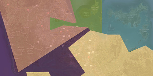
For the first time, Aucklanders can clearly see the proposed changes to their street and neighbourhood under the Unitary Plan.
The Herald has obtained the raw data, released under an OIA request, behind the mammoth plan and simplified the changes into a map of the city.
The map shows the latest data from the recommendations. It does not include further changes flagged by the Auckland Council.
The map shows the residential, rural and commercial zones, which set out what can be built, where and to what height buildings can go.
The map shows a big drop in the traditional single house zone, which has shrunk by 22 per cent across the region and 42 per cent in the central isthmus.
It gives a picture of more intensive housing in centres likes Takapuna, Albany and Henderson and along main transport corridors.
The areas in dark blue, around rural towns like Pukekohe and Warkworth, are a Future Urban zone earmarked for housing over the next 30 years.
The Herald's map is a simplified version of maps on the Auckland Council website, which some people have found hard to navigate and understand.
The proposed plan permitted 296,000 new homes over the next 25 years.
An independent hearings panel has recommended 422,000 homes in the latest plan.
Councillors will meet tomorrow to begin making decisions on the recommendations.
Final decisions will be notified on the council website on August 19.